


djlewis
-
Posts
1,649 -
Joined
-
Last visited
Content Type
Store
Downloads
Events
Forums
Gallery
Posts posted by djlewis
-
-
Can somebody explain Image 1?
-
Very neat -- thanks!
I now appreciate why a decent carbon fiber paddle costs $400-500. BTW, looks like Novorca's go for up to $1000, depending on options -- http://novorca.com/prices/
-
djlewis, thanks very much for the info! That sounds worth a try, although I like using Pavilion Beach since it's closer to my house. (And there's no fee for parking.)
I may be over-optimistic, but my seat-of-the-pants estimations suggest that--unlike the Castle Neck circuit--the PI circuit can be done mostly with the current, maybe entirely. I guess it depends where the floods meet on the inside. I'm game to try your approach, but I'd also like to try my original plan (leave Pavilion two hours before high, and go up the inside).
Your launch point and timing will work pretty well, except for entering Ipswich Bay against the ebb, which is usually not that big a deal. And depending on how leisurely you are, you could wind up back at Pavilon near low tide, which entails that annoying hike across the tidal flat.
As for trying to be with the current absolutely everywhere, bear in mind that the tide (obviously) generates vastly different currents at different places.
-
Ii haven't thought about your theoretical questions, but here's how I do that circuit to optimize for tides and currents
Go clockwise and launch from the beach near the northern end of Plum Island, on the western side -- http://goo.gl/maps/rzMVy. Schedule launch to catch the end of the ebb current from the mouth of the Merrimack. That gets you out the mouth of the Merrimack, just minutes from the launch point, in relatively calm and slightly favorable tidal current.
Then, after slogging down the outside you enter the mouth of the Ipswich opposite Pavilion beach on mid-flood, going with the current, which avoids any roughness due to outgoing tide against incoming swell. On the inside you are on rising tide, which put the current with you through most of the narrow part of the route, where it matters most. Finally, you reach the area north of the Plum Island Turnpike Bridge at fairly high and rising water, which avoids the annoying shallows in that area. The current may be a bit against you by then, but since it's fairly open it doesn't matter much.
Of course, except for the shallows, you can forget all the avoidance of rough water and opposing current and just go have some fun challenging yourself.
At that launch point you can park at the top of the beach by paying $5 in the bait shop, or park for free in the large parking lot across the street.
-
If memory serves, I think the two experienced paddlers who got caught out and capsized in big conditions in Plum Island Sound did use handheld flares, but only after the CG got relatively close based on VHF contact. The flares helped the rescuers pinpoint the rescuees in the final phase of approach.
The whole story is in somewhere the archives, if anyone wants to verify details.
-
Hey, flares and knives are how we peaceable woodland creature/kayakers get to express our inner Rambo.
 (our is it our inner Rimbaud?)
 -
Gee... the dolphin just swam off without saying "thank you". Ungrateful critter.
-
The rafting was relatively easy. The impressive part was that one of the paddlers at the outer edge towed the rest of the raft.
I didn't see that in the story. Was it you daydreaming about feats?
-
-
- "... had all the feel of a practiced rescue technique ..."
- "... video from another paddler that got stuck in the same spot ..."
Putting those two observations together, wonder if they actually had "practiced" this rescue before, perhaps more than once. If so, it raises some other issues.
-
Thanks to Bethany Ericson and Catherine Foley.
-
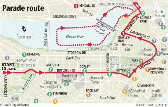
Yup -- this story on Boston.com confirms your report, Pru...
Boston Police Superintendent-in-Chief Daniel Linskey... said a security zone would be created on the river starting at 10 a.m. that will remain in effect until 2 p.m. Anyone who violates that zone – in the past people have swum into the area and kayaked into the area – will be arrested, he said. The Coast Guard, Environmental Police and other public safety agencies with marine units are assisting with security.
He also said that the duck boats will travel further away from the shore than they have in the past. And he asked parade attendees not to throw baseballs or other objects out towards the players, which has also happened previously.Understandable.
-
I bet security will be as it was for the fourth of july - no one will be able to get close to the duck boats on private craft. I would imagine they'd have that part of the river blocked off...
pru
Yeah, probably true -- sigh.
But for the Fourth, I though boats could get on that part of the river. Never did it myself, but have heard tales (probably here). IIRC, the problem was competing with wall-to-wall powerboats -- it took literally hours to get out, as the flotilla unwound.
-
Just a thought. Anybody try it before? Wonder what the security will be like.
-
I've had excellent luck with United Divers in Somerville. The lady who does their drysuit repair is a whiz at it -- she fitted me perfectly and recommended no trimming, which was against my own instinct but turned out to be correct. They have more sizes than Kokatat, and their neck gaskets are heavier duty.
If you do have a Kokatat suit, however, sending it in has a big advantage -- they will thoroughly test your suit for incipient leak and delamination, and if they find any, quite likely repair or replace for free. It does take a lot longer, however, and at this time of year they are probably backed up (as are all places).
-
Go to http://www.kayakpaddling.net/
Click on "safety basics"
scroll down to "assisted re-entry (heel hook)"
That animation is not bad, and the written "narration" hints at the technique with -- "After the heel is hooked inside, it is fairly easy for the swimmer to pull himself on the rear deck by using his leg muscles" (emphasis in original). But that's more of an explanation of what's happening than instructions on how to execute the re-entry. And it's accurate, except that it's more of a roll up on the deck than a pull (and trivially, your heel isn't hooked at first, your whole foot is).
To actually execute the maneuver, however, the rescuer should just say "straighten that leg" and it will happen, as if by magic. She shouldn't tell the swimmer to use his leg muscles to pull himself on the rear deck. It's just the way your car starts when you turn the key -- you don't have to think that you are sending current to the starter's electric motor, etc etc. It just happens!
-
...once you have your toe under the coaming, you simply straighten your leg and while holding onto the rescuer's deck lines (or yours if you can't reach), you roll your upper body onto the deck. People usually get very bruised when they are trying to shove the leg deep into the boat and 'working' to get in rather than using the leg as a lever.
I agree that "straighten your leg" is a key instruction. Here's the complete sequence I use, and it generally works, even with people who have never done it...
- Bring the boats side-by-side facing opposite directions, swimmer on the outside near their cockpit
- Say -- get next to your cockpit, facing forward, hand lightly on the coaming
- Make sure you have their boat firmly gripped the usual way
- Say -- swing your outer leg (or specify which one that is) up into the cockpit and hook your foot under the front of the coaming
- Say -- now straighten that hooked leg
- They should automatically start to roll up onto their boat
- Say -- if necessary, grab your far deck line or my deck line
- Say -- bring your other leg into the cockpit, stay low to your boat and slip forward into the cockpit
- Say -- stay low and centered in your cockpit and turn yourself upright
Unfortunately, the above video does not seem to use the "straighten your leg" instruction. Instead, it looks to me like the swimmer is pulling herself up onto the boat with her arms at 0:21 to 0:25.
I just went through a bunch of videos on the web, and not a single one clearly shows and narrates the leg straightening technique; in fact, most do not even seem to use it. One of the self-rescue clip kinda-sorta shows it, but with no narration and a not-so-great camera angle, nobody will see that.
This is all so strange to me. When I first tried this technique (I did not hear the name "heel hook" until much later) I was given that clear instruction, and before I knew it (and despite my skepticism), without any further maneuvering or instructions, I was rolling onto the boat and into the cockpit. It was almost shocking how easy it was. But that technique and the ease seem to have gotten lost, and now it's just an alternate way to position yourself so you can use your upper body to pull yourself onto the deck by the lines.
-
Call RackAttack in Framingham MA. They are excellent in finding a perfect configuration for most any need and will install on the spot. I think Thule is over rated and over priced. I would look at Yakama as I believe their quality across the board is better but that's just my opinion.
Doug
Yakima has one big advantage in my book -- the round bars make it possible to swivel the saddles (or whatever) 360 degrees.
I find that useful in a number of ways. For example, I can move my boat directly from straps on the garage wall to the roof rack, but because of tight clearances it requires swiveling the two outside saddles upside down in the midst of the process. I also have a stacker that I occasionally use to fit more than two boats on top, but I just leave it swiveled out of the way most of the time, so I don't have to remove/replace it.
Can Thule do either of those?
-
Top-notch pictures, Pru. Just to single out a few -- the rock shots are great, and #48 proves it is possible to make a good photograph with a distant shot of a kayak and a lotta water.
--David
-
Is there anyone out there who has better direct comparison data between surfskis and SIKs with identical hulls or know of other theoretical reasons that might suggest a speed advantage of one over the other? Someone who’s switched from an 18X Sport to the V8 (or an18R to the 18S) might be in a good position to judge.
Interesting question. Seems like what you want is a test-tank comparison of actual drag and forces on the hull (or whatever they call those measurements). In actual paddling there are so many variables, measurable and unmeasurable, that a meaningful real-life comparison may not be possible. Steering and rudder issues, in particular, including center of gravity as it affects turning, would also have to be technologically isolated, which might be beyond current technology (from what little I know about it).
So, why not suggest it to one of the magazines that have the equipment and expertise for such tank testing, at least in a straight line. I don't know much about those tests, but, when the question is isolated to a pure hull test in a tank, perhaps the answer will be obvious: the same hull ==> the same performance, in that abstract sense. But still, they might be able to quantify effects of drag of the drainage system, weight differences, etc.
-
Further to the north you will also find the MIsery Islands which have welcoming landings and interesting places to walk and view the harbour.
But don't forget the landing fee on the Miseries in summer -- either show a Trustees of the Reservations (or whatever they call it now) card or pay something like $4 (anybody know the current fee?)
-
Hi Brenda, A couple of other tricks to try coping with weathercocking in wind that I don't think have been mentioned in this thread...
One more trick when there is chop or swell (which there usually is in wind)... Adjust the timing of your stroke (by accelerating or delaying slightly) to catch the "fat" part of the wave on the upwind side with every or most strokes. That turns the bow more effectively downwind because it's up on the wave and thus a bit more out of the water and partly released. It may also give the paddle a tad more purchase on the upwind side.
-
You need to consider that one of you could find yourself swimming and must have the means to return to your boat.
I was out on the Charles once near MIT and came upon three paddlers in two boats. Well, the one in the single wasn't a paddler anymore, he was a swimmer, and had been struggling for 30 minutes to get back into his boat with less than a full load of water. I retrieved his paddle, emptied his boat with a T and got him back in with a heel-hook, and they paddled off, amazed and grateful. He wasn't in any danger -- calm, warm water, near the bank -- but think what might have happened a couple hundred yards from shore, maybe with breakers, 65F water rather than 75F, etc.
-
Hi everyone
I just joined NSPN, having finally purchased a kayak (Tiderace XCape - 17'). I consider myself a beginner, but according to your definitions, I meet the level 3 guidelines. I want to take a friend out who is probably a level 2, in the next couple of days. We both live in Lexington, and have been out a few times on the Concord, Mystic, and Nashua Rivers. Our paddling trips have been about 6 to 8 miles round trip, and that is probably what we would like to do. Any good suggestions? BTW we are both proud carriers of medicare cards.
Dave Meharry
Another non-salt venue to consider is the Charles River. You can launch from any of several Charles River Canoe and Kayak locations for a variety of interesting round trips in that range. Look especially at the relatively new CRCK site in Nahanton Park, which eases accessibility to a lovely stretch of the Charles that used to be fairly obscure. If your friend lacks a boat, launching from a CRCK center gives her or him the opportunity to rent one. If he has a boat, then there are other launch points, or you can still launch at CRCK docks for free and get a bit of advice and assistance from their staff.
If, on the other hand, you are looking for salt water paddling, there are a many launch sites and trips of that length around the Boston area. But safely going out on even protected ocean routes demands more training, preparation, equipment and guidance, especially as we move into the Autumn months.

Impressive skies
in General Message Board
Posted · Edited by djlewis
Aha! Thanks. Knowing that, I found more...
http://www.dailymail.co.uk/news/article-2260560/Wall-sand-whipped-Tropical-Cyclone-Narelle-hits-Onslow-Western-Australia.html
What's this got to do with kayaking? Well, it may not happen very often, but it might be useful to recognize a sandstorm blowing your way while offshore. Of course, you may want to remain offshore for a while, as what's happening on land may be worse. As with a tsunami, your best bet may be to paddle out to deep water before it hits, rather than towards shore.